All categories
Featured selections
Trade Assurance
Buyer Central
Help Center
Get the app
Become a supplier
(1708 products available)


 Ready to Ship
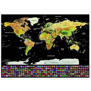
A world map with flags shows the countries of the globe and their flags. It is a simple way to introduce children to geography and the different countries around the world. There are different types of world maps with flags, including;
Political world map with flags
A political world map with flags shows the political boundaries of the countries worldwide. The boundaries are marked with different colors to make the countries stand out. Each country is filled with its flag, making it easy to identify them. A political world map with flags is used in schools to teach children about countries and their flags. It is also a great tool for anyone interested in learning about the world. It is available in different sizes and can be hung in an office or children's room.
Physical world map with flags
A physical world map with flags shows the natural features of the Earth. It uses different colors to show the elevation of the land. Mountains are shown in brown, while bodies of water, such as rivers and oceans, are in blue. The flags make it easy to see where each country is located on the map. A physical world map with flags is a great tool for teaching children about geography. It is also helpful for travelers and those interested in learning about the Earth's natural features. It is available in different sizes, from small to large. Buyers can also get one with a magnifying glass and a stand or a wall map.
Vintage world map with flags
A vintage world map with flags has an old-world design. It has a decorative style that features compass roses, sea monsters, and ships. The countries are filled with their flags, making it easy to see the different countries on the map. A vintage world map with flags is popular among collectors and history enthusiasts. It is also a great decorative piece for homes, offices, and schools. It comes in different sizes and materials. Some are printed on paper, while others are on canvas or wood.
Purpose
Establish what the world map with country flags will be used for. Is it for decorative purposes, educational use, or to plan travels? The purpose will guide the selection process. For instance, if the map is to be used in a classroom, a detailed flags of the world map showing country boundaries, capitals, and major physical features will be most appropriate. However, if the map is for a travel blog, a more general map highlighting personal travel routes may work well. Therefore, understanding the purpose will help ensure that the world map serves its intended function effectively.
Detail Level
Consider how much detail is needed on the map. World maps with flags can range from highly detailed ones showing every country and major city to more simplistic ones with just the countries and their flags. If the map is for educational purposes, a highly detailed one showing all countries with flags, major cities, and geographical features would be best. However, for a general overview or decorative purposes, a simpler map may suffice.
Visual Clarity
A world map with flags needs to be visually clear and easy to read. This includes using colors that contrast well and a font that is legible from a distance. When looking at a world map with flags, one should not strain their eyes trying to read it. Good visual clarity ensures that the map can be used effectively, whether for teaching, planning, or decoration.
Material and Durability
The material of the world map is also an important consideration. Maps can be printed on paper, canvas, or even specialized materials like vinyl. Each material has its longevity. For instance, a canvas map may last longer because it is more durable than a paper map. If the world map will be used in a location where it may get wet or spilled with drinks, a vinyl or laminated map would be best since they can be cleaned without damaging the map.
Interactivity
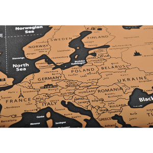
Think about whether an interactive map would be beneficial. Interactive world maps with flags can include features like scratch-off countries, pin boards, or digital maps that allow for zooming and clicking on flags for more information. These interactive elements can enhance the map's educational value and make it more engaging for users.
Personalization
A personalized map can make the world map more unique and meaningful. Personalization can include custom flag placements, labels for personal travels, or even having a map commissioned with specific features. Personalization adds a personal touch to the world map, making it a cherished piece.
A world map with flags is a valuable educational tool for teaching geography and exploring different cultures. However, it's essential to consider the safety and quality of these maps to ensure they are durable, accurate, and safe for use in various settings.
Safety considerations for a world map with flags primarily involve the materials used in its production. This is particularly crucial for maps intended for use in schools or by younger audiences. The map should be made from non-toxic materials. It should also have a smooth surface without sharp edges or loose parts that could pose a choking hazard. Additionally, a world map with flags should have a sturdy construction. The flags should also be securely attached to prevent them from being pulled off easily.
Quality is one of the most important things to consider when looking at a world map with flags. The map should be made from high-quality materials that are durable. This ensures that it can withstand frequent handling and last for many years. Additionally, the printing of the map should be clear and precise. This helps to enhance its visual appeal and readability. A good map should also use vibrant colors that accurately represent different countries and their flags.
Another quality aspect to consider when looking at a world map with flags is its level of accuracy. The map should have a detailed and accurate representation of the world. It should also include all countries, continents, and major geographical features. Furthermore, the flags should be correctly placed, representing the respective countries. The map should also include a comprehensive key or legend that helps users identify the flags and their corresponding countries easily.
In conclusion, safety and quality are crucial considerations for a world map with flags. Ensuring the map is made from safe, non-toxic materials, and has a sturdy construction, will make it suitable for use in various settings. Moreover, an accurate, high-quality map will serve as a valuable tool for learning about the world and its diverse cultures.
What is the purpose of a world map with flags?
A world map with flags is both an educational and decorative tool. It helps people learn about different countries and their flags, making it useful for schools, travel planning, and promoting cultural awareness. The map can also be a stylish addition to any room, showing the countries one has visited and celebrating global diversity.
How to use a world map with flags in the classroom?
A world map with flags is a versatile tool for teaching geography, culture, and global awareness. It can be used to identify countries, learn their flags, and find major cities and physical features. Teachers can use it to introduce new countries, discuss current events, and explore cultural diversity. It's a valuable resource for various subjects and activities that broaden students' horizons.
What materials are commonly used to make a world map with flags?
World maps with flags are made from various materials, each offering unique benefits. Paper or cardstock is the most common choice, as it is affordable and easy to print detailed maps and flags. However, they can wear out quickly if exposed to moisture or sunlight for long periods. Laminating paper maps or using vinyl makes them more durable and suitable for outdoor use since they resist water damage and fading.
How to maintain and care for a world map with flags?
To keep a world map with flags looking good and lasting long, it is essential to take care of it properly. It should be placed where sunlight cannot reach it directly because it can make the colors fade. If it is a paper map, keeping it in a dry place and not letting water spill on it is vital as it can get damaged. Cleaning the map gently with a soft, dry cloth will also help remove any dust or dirt without scratching the surface.