All categories
Featured selections
Trade Assurance
Buyer Central
Help Center
Get the app
Become a supplier
(836 products available)


 Ready to Ship


 Ready to Ship


 Ready to Ship


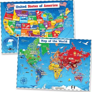
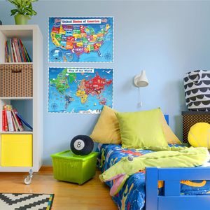


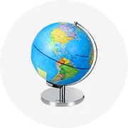
world map elementary are essential tools in the realm of educational supplies, specifically designed to enhance the learning experience by providing visual and tactile aids for understanding geographical concepts. These products, often found in classrooms and educational institutions, serve as invaluable resources for teaching students about the world, its landscapes, and its diverse cultures. world map elementary are crafted to cater to various learning needs, offering both detailed and broad perspectives on geography. They come in a range of formats, including maps, globes, atlases, and interactive software, each contributing uniquely to the education process by making abstract concepts more tangible and accessible.
The market offers a diverse array of world map elementary, each tailored to specific educational requirements. Traditional paper maps and globes remain popular choices, providing a physical representation of the earth's surface and facilitating hands-on learning. Digital maps and interactive software have gained traction, offering dynamic and engaging ways to explore geographical data. Atlases, which compile a collection of maps, serve as comprehensive references for both students and educators. Additionally, topographic models and relief maps provide three-dimensional perspectives, enhancing the understanding of physical geography. Each type of world map elementary is designed to address different aspects of geographical education, enabling educators to choose the most appropriate tools for their teaching objectives.
world map elementary are integral to geographical education, offering a variety of functions and features that support learning. They help students visualize spatial relationships and comprehend the scale and distance between different locations. Many world map elementary are equipped with detailed legends and keys, aiding in the interpretation of symbols and data. Some products feature interactive components, such as touch-sensitive screens or augmented reality capabilities, which engage students and foster active learning. The durability and portability of these supplies also contribute to their effectiveness, allowing them to withstand frequent use in classroom settings. By incorporating these features, world map elementary facilitate a deeper understanding of geography, fostering students' curiosity and expanding their knowledge of the world.
The production of world map elementary involves the use of various materials, each chosen for its specific properties and suitability for educational purposes. Paper and cardboard are commonly used for maps and atlases, providing a lightweight and cost-effective medium for printing detailed geographical information. Globes often utilize sturdy plastic or metal bases, ensuring stability and longevity. Digital geography supplies rely on electronic components and software, offering interactive and up-to-date representations of geographical data. The choice of materials impacts the durability, clarity, and usability of world map elementary, allowing manufacturers to tailor these products to the needs of educators and students. As technology advances, the integration of sustainable materials is becoming increasingly important, aligning with the growing emphasis on environmental responsibility in education.
Maximizing the benefits of world map elementary requires an understanding of their capabilities and limitations. Educators should select the appropriate type of product based on the specific learning objectives and the age group of the students. For instance, younger students may benefit from tactile and visual aids such as globes and relief maps, while older students might engage more with digital maps and interactive software. Incorporating a variety of world map elementary into lessons can provide multiple perspectives and cater to different learning styles. It's important to provide guidance on interpreting and analyzing geographical data, helping students develop critical thinking skills. Additionally, integrating geography supplies with other subjects, such as history or science, can enrich the learning experience and demonstrate the interconnectedness of knowledge. Proper storage and maintenance of these supplies are essential to ensure their longevity and continued effectiveness in the classroom.
When selecting the appropriate world map elementary for educational settings, it's essential to consider the specific learning objectives and the age group of the students. Different types of geography supplies cater to various educational needs, so understanding these requirements is crucial. For instance, tactile aids such as relief maps and globes can be particularly beneficial for younger students who are developing their spatial awareness. On the other hand, digital maps and interactive software may be more suitable for older students who can engage with complex geographical data. It's important to evaluate the features of each world map elementary, such as the level of detail, interactivity, and durability, to ensure they align with the educational goals.
Another factor to consider is the integration of world map elementary with other subjects. Geography supplies can be effectively used in conjunction with history and science lessons to provide a multidisciplinary learning experience. By doing so, educators can illustrate the interconnectedness of geographical, historical, and scientific knowledge, fostering a more comprehensive understanding among students. Additionally, the choice of world map elementary should reflect the cultural diversity and global perspectives present in the curriculum, allowing students to explore various regions and cultures.
To maximize the educational impact of world map elementary, educators should integrate them into lesson plans in a way that encourages active learning. This involves guiding students in interpreting geographical data and fostering critical thinking skills. Hands-on activities, such as creating map projects or using interactive software, can engage students and make geography more relatable. Additionally, providing context and background information for the geographical concepts being studied can enhance understanding and retention.
Digital world map elementary offer several advantages, including the ability to present up-to-date information and interactive features that engage students. These supplies often include visual and auditory elements that can cater to different learning styles, making them a versatile tool in the classroom. With digital geography supplies, students can explore various regions and landscapes in real-time, gaining a deeper understanding of global dynamics and geographical phenomena.
world map elementary play a vital role in helping students develop spatial awareness by providing visual and tactile references for geographical concepts. Supplies like globes and maps allow students to visualize spatial relationships, such as distance and direction, which are fundamental to understanding geography. Through activities like map reading and navigation exercises, students can enhance their ability to interpret spatial information and apply it to real-world scenarios.
Yes, there are sustainable options available for world map elementary. Manufacturers are increasingly incorporating eco-friendly materials and practices in the production of geography supplies. For example, maps and atlases can be printed on recycled paper, and digital supplies can reduce the reliance on physical materials. Educators can contribute to sustainability by choosing products that are durable and designed for long-term use, minimizing waste and promoting environmental responsibility.
Customization of world map elementary can be achieved by tailoring the content and format to meet specific educational needs. Educators can select supplies that focus on particular geographical regions, themes, or concepts relevant to their curriculum. Additionally, digital geography supplies often allow for customization, such as adding layers of information or adjusting the level of detail presented. This flexibility ensures that geography supplies are aligned with the learning objectives and can effectively support the educational process.