Introduction to Texas Wall Map
A Texas wall map is an invaluable tool for anyone looking to enhance their geographical understanding of the Lone Star State. Whether you're a business owner, an educator, or simply an enthusiast of all things Texas, these maps provide detailed visual information that is both practical and aesthetically pleasing. With vibrant colors and clear markings, a Texas wall map serves as an informative decor piece that can brighten any room while providing essential insights into Texas's diverse geography, counties, highways, and landmarks.
Types of Texas Wall Maps
Texas wall maps come in various styles and formats to suit different needs. Here are some common types:
- Political Maps: Show the state’s boundaries, major cities, and transportation routes, highlighting political divisions.
- Physical Maps: Focus on the natural features of Texas, including mountains, rivers, and forests, made for those who appreciate geography.
- Road Maps: Provide detailed information on highways and roads, perfect for navigation and travel planning.
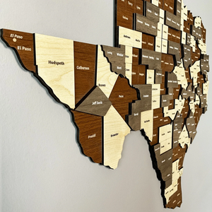
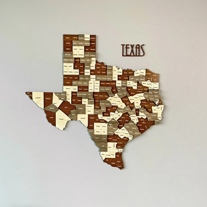
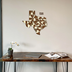
- Decorative Maps: Designed for aesthetic appeal, these maps often incorporate historic elements and artistic styles, making them great for home or office decor.
- Topographic Maps: Indicate landforms and elevations, highly suitable for outdoor enthusiasts and those interested in hiking or land development.
Function and Feature of Texas Wall Maps
Texas wall maps are not just about aesthetics; they are designed to be functional and packed with features:
- High-Quality Material: Most Texas wall maps are printed on durable, tear-resistant paper or materials that can withstand time and usage.
- Legible Fonts and Graphics: Clear symbols and font sizes ensure readability from a distance, making them suitable for classrooms and offices alike.
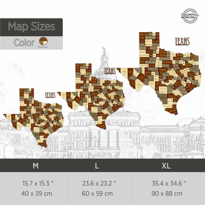
- Diverse Scale Options: Available in different scales, from city-specific maps to state-wide representations, catering to varying detail requirements.
- Laminate Finish: Some maps come with a lamination option, allowing users to write, erase, and clean the surface if used for instructional purposes.
- Incorporated Landmarks: Many maps highlight famous landmarks, parks, and historical sites, making them great conversation starters.
Applications of Texas Wall Maps
Texas wall maps have numerous applications across various sectors. Their practicality spans beyond decorative purposes:
- Educational Tools: Teachers can use these maps in classrooms to enhance geography lessons and improve student engagement.
- Business Planning: Excellent for businesses looking to establish services in Texas, helping in market analysis and territory planning.
- Event Planning: Useful for planning events, festivals, or conferences, where geographical awareness is crucial for logistics.
- Local Navigation: Home and office users can utilize these maps for personal navigation or travel planning in Texas.
- Aesthetic Home Decor: Adding aesthetic value to living spaces while serving as a unique conversation piece among guests.
Advantages of Using a Texas Wall Map
Investing in a Texas wall map brings various benefits:
- Enhanced Knowledge: Provides a visual representation that improves understanding and memorization of state geography.
- Cultural Awareness: Fosters appreciation for Texas's rich history and diversity through its landmarks and geographical features.
- Easy Accessibility: Offers quick reference for anyone needing geographical information about Texas.
- Durable Display: A well-made map retains its integrity and appearance over time, becoming a centerpiece of decoration.
- Versatile Usability: Enjoyable for all ages, from students learning about geography to adults interested in exploring the vast Texas landscape.