All categories
Featured selections
Trade Assurance
Buyer Central
Help Center
Get the app
Become a supplier
(926 products available)


 Ready to Ship
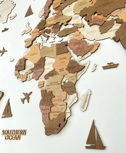


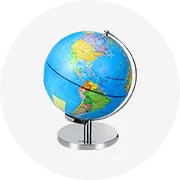
Map capitals are maps that show the capital cities of different countries around the world. The capital city is where the government of a country is located. It is usually the most important city in a country. There are different types of map capitals. Below are the major types.
The first type is Political map capital. Political maps show capital cities and other important cities. It also shows the boundaries of countries, states, or regions. The boundaries are sometimes referred to as political borders. A political map indicates where political entities are located. There are two main types of political map capital. They are thematic and reference political maps. Reference political maps are made for textbooks and classrooms. They show capital cities and other cities in a state or country. They also show boundaries and important geographical features. On the other hand, thematic political maps focus on one specific topic. For instance, population distribution, election results, natural resources, etc.
The second type is Physical map capital. Physical maps show geographical features of a place. For example, mountains, rivers, lakes, valleys, deserts, etc. These features are shown using different colors. For instance, blue is used for water bodies like rivers and lakes. While mountains and hills are shown in grey or black. The capital cities are highlighted in red.
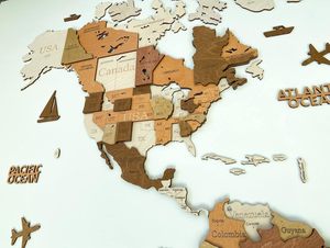
The third type is World map capital. These maps show capital cities of different countries in the world. They indicate the location of each capital city in relation to other cities and countries. World maps can be political or physical. They can also be thematic. The capital cities are represented using symbols or dots.
The fourth type is Map capitals for kids. There are maps specifically designed for kids. These maps are simple and easy to understand. They show capital cities and important geographical features. Additionally, they have fun facts that kids will find interesting.
The fifth type is Blank map capitals. These are maps without any markings. They are used for practice to help people learn how to locate capital cities and other important features. People can fill in the blanks to indicate the location of capital cities.
Map of capitals has several features and functions that enhance their educational value and make them more interactive. Some of the essential features include:
Physical and Political Maps
Physical maps of the capital show the landscapes, mountains, rivers, and other geographical features. Political maps show the boundaries, regions, states, and the location of the capital cities within a country or continent. These maps help in understanding the political and physical layout of an area.
Detailed Information
The map displays detailed information about the capital cities. This includes population, location coordinates, historical significance, cultural importance, and economic data. This information helps in understanding the capitals better.
Interactive Features
Some maps are interactive, allowing users to click on specific areas to obtain more information. This feature is common in online maps, which are user-friendly and easy to navigate.
High-Quality Imagery and Graphics
Maps of the capitals are well-illustrated with high-quality images and graphics. This makes them visually appealing and easy to read and understand. The high-quality graphics capture the attention of the user, making the learning experience enjoyable.
Clear Legends and Scales
These maps have clear legends and scales that help users understand the symbols and the size of the areas represented. This feature is essential for accurate reading and comprehension of the map.
Educational Value
Maps of the capital are essential educational tools. They help students and researchers learn about geography, political science, and history in a visual and interactive way. The maps make learning more accessible and enjoyable.
Customizable Options
Some capital maps offer customizable options where users can choose specific regions or countries of interest. This feature enables targeted learning and exploration of particular areas.
Quality and Durability:
Selecting capital maps made from high-quality materials is essential to ensure longevity and durability. Consider factors like the type of paper or material used, the printing technique employed, and the map's finish (matte or glossy). High-quality materials resist wear and tear, fading, and tearing, ensuring that the capital map remains clear, readable, and aesthetically pleasing for years.
Target Audience and Purpose:
The target audience and purpose of the capital map should be the primary considerations when choosing it. Different audiences have different needs when it comes to maps. A political science student or a researcher may need a detailed, well-labeled map that shows the political boundaries and capital cities. On the other hand, an artist may require a capital map with a unique, minimalist design suitable for wall art or a poster. Understanding who will use the map and for what purpose helps determine the right type and style of map that meets those specific needs and requirements.
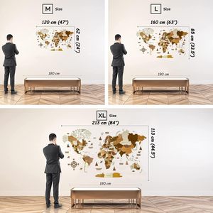
Size and Format:
When buying capital maps in bulk, it's essential to consider the size and format of each map. Capital maps come in different sizes, from small, pocket-sized maps that are convenient for carrying and personal use to large, poster-sized maps that are ideal for display purposes. Each size has its advantages and disadvantages depending on the intended use. For instance, larger maps provide more detail and are easier to read from a distance, while smaller maps are more portable and easy to store. The format is also important, as maps can be presented in different formats such as folded, rolled, or flat. Each format has unique characteristics, and understanding these characteristics makes it easy to choose the right one suitable for specific needs.
Q: How are the capital cities of each country determined?
A: The capital city is usually determined by the central government. Leaders decide which city will be the capital and that city usually hosts important government functions like meetings, decision-making, and other activities. The leaders have to agree on a city to make it the capital.
Q: Why are capital cities chosen?
A: Capital cities are chosen for several reasons. They have to be accessible so that people from all parts of the country can reach them easily. They have to be safe and stable. The capital city also needs to have the necessary resources to host government functions.
Q: What makes a good capital city?
A: Several factors make a good capital city. It should be politically neutral. It should also have a strong economy to support government functions. A good capital city should have good infrastructure and a good education system.
Q: What is the difference between the capital and the largest city?
A: The capital city is where the government is located. It controls and governs the country. The largest city, on the other hand, is home to most people. It is usually the most developed and has a lot of resources.