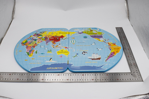
Introduction to Large World Map
A large world map serves as more than just a decorative piece; it is a vital educational tool and a conversation starter. Whether hanging in a classroom, an office, or a home, these maps provide a visual understanding of geography, encouraging exploration and discovery. With intricate details and vibrant colors, large world maps are designed to captivate and educate people of all ages.
Types of Large World Maps
- Political World Maps: These maps focus on country borders and capitals, helping users understand political divisions and relationships.
- Physical World Maps: Highlighting mountains, rivers, and other geographical features, these maps are ideal for those interested in the natural landscape.
- Topographic World Maps: These maps display elevation changes and landforms, providing insights into the terrain of various regions.
- Historical World Maps: Showcasing the world as it was at different points in history, these maps are perfect for educational settings or history enthusiasts.
- Customized World Maps: Tailored to specific preferences, users can have maps that feature personal travel routes or locations significant to them.
Applications of a Large World Map
- Educational Institutions: Large world maps are invaluable teaching aids in schools, helping students visualize geography, cultures, and global dynamics.
- Corporate Settings: They can enhance the atmosphere in offices, serving as tools for team-building and strategy sessions focused on global markets.
- Home Decor: As a statement piece, a large world map can transform a dull space into a vibrant room, appealing to travel enthusiasts and adventurers.
- Travel Planning: Displaying a large world map at home or in a travel agency can spark inspiration for future travels and adventures.
- Geographical Research: These maps are essential resources for researchers and professionals who require a comprehensive visual understanding of global locations and features.
Features and Advantages of Using a Large World Map
- High-Quality Printing: Most large world maps use advanced printing technology that ensures vibrant colors and clear details.
- Durable Materials: Fabricated from water-resistant and tear-proof materials, these maps are built to last, making them suitable for various environments.
- Educational Value: They promote curiosity in children and adults alike, making geography interactive and engaging.
- Easy Navigation: Featuring easy-to-read labels and geographic markers, large world maps simplify the understanding of distances and locations.
- Versatile Placement: These maps can adorn walls, desks, or even be rolled out during presentations and meetings, providing flexibility based on the user’s needs.