All categories
Featured selections
Trade Assurance
Buyer Central
Help Center
Get the app
Become a supplier
(1201 products available)

 Ready to Ship


 Ready to Ship


 Ready to Ship

 Ready to Ship
Electronic Total Stations
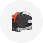
Total stations are pivotal instruments, amalgamating electronic theodolite and EDM (Electronic Distance Measuring) functionalities. Using electronic total stations, surveyors can glean measurements with superior expediency and accuracy. They are extensively applied in construction, mapping, and land surveying domains. Usually, they hold a Robotic version that enables a single surveyor to track and measure from a distance, thereby proving indispensable for projects where few personnel can be present.
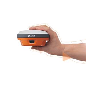
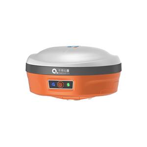
Global Positioning System (GPS) Surveying Equipment
GPS surveying equipment has transformed the realm of land surveying by promising accurate location tracking globally. Surveying with GPS equipment allows surveyors to swiftly establish property lines, delineate boundaries, perform topographic surveys, and garner geospatial data. Its applications span construction, civil engineering projects, and natural resource management. Modern architectures invariably factor in multi-constellation and multi-frequency GPS receivers to produce high-precision measurements.
3D Laser Scanners
Scanners represent a cutting-edge method for fetching spatial data in a diminutive lapse. These instruments generate dense point clouds depicting structures, terrains, and interiors, which lead to the formulation of accurate 3D models. The construction, historical preservation, and mining industries have mandated these scanners for documentation and analysis prerequisites. Additionally, they authenticate fast data acquisition without encroaching on the need for physical measurements.
Digital Levels
Digital levels are tailored principally for height and leveling measurements. They are an upgrade over classical leveling, adopting electronic sensors for automatic readings. This subgroup of equipment lowers human error while increasing measurement speed. Digital levels are regularly employed in establishing benchmarks, surveying sites, and executing excavation work. Their user-friendly interfaces further enhance efficiency on-site.
Static and Kinematic Surveying Systems
Static and kinematic surveying systems are distinctive in their methods of data collection through GPS. Static surveying engages stationary GPS receivers over elongated time spans, thereby achieving the utmost gravimetric accuracy. In contrast, kinematic surveying infrastructure in motion with mobile GPS units, suitable for real-time applications such as vehicle routing and tracking construction machinery. Both techniques embraced variably in topical and geodetic surveys alike. They are integral to expansive and intricate projects deploying mass data for precision-engineering in an array of scenarios.
Construction and Civil Engineering
Surveying equipment are instrumental in the construction phase, from the conceptual stage to the completion of a structure. They delineate property lines, stake out building positions, and forecast soil mechanics. Precision in these measures erases potential redesigns and budget overruns birthed from errors in the placement of structures or misinterpretation of site topography. Furthermore, as construction progresses, these tools recapture and verify as-built conditions against initial blueprints, ensuring the venture substantially adheres to its design and regulatory compliance.
Land Surveying and Mapping
Land Surveyors virtuously apply electronic equipment to delineate accurate maps and maintain property boundaries. From topographic surveys that analyze land formation patterns to cadastral surveys focusing on land ownership and legal boundaries, the devices assure state-of-the-art precision. GPS and total stations are especially effective in producing comprehensive and faultless land survey maps. Accurate surveys are paramount, offering vital information for real estate, urban planning, and environmental forecasting projects.
Environmental Monitoring and Management
Electronic surveying tools are used to address ecological concerns progressively. They are pivotal in mapping such habitats for wildlife, forests, and wetlands, helping formulate conservation strategies. These tools also participate in monitoring alterations within landscapes over time due to phenomena such as climate shift or human intervention. Accurate data is critical to recognize patterns, evaluate risks, and draw effective responses to ecological predicaments. Hence, these surveys support ecological health and stability mitigation risk-oriented models for different ecological predicaments.
Mining and Resource Extraction
In mining and resource extraction, positioning and preliminary site analysis are crucial. Earth-scanning equipment provide valuable three-dimensional models of terrain, helping industries pinpoint deposits of minerals or other valuable resources before commencement. This due diligence conserves time and monetary resources by preventing the deconstruction of non-depositional land. Moreover, as mining progresses, these tools facilitate continuous topographical and geological surveys, guaranteeing both safe work molding and vigilant resource optimization.
Transportation and Infrastructure Development
Surveying equipment surveys are equally critical in roadways, railways, and other transportation system designs. With these instruments, planners can analyze suitable routes, level ground, and evaluate potential impediments to the proposed infrastructure. GPS and laser scanning ascertain great accuracy in monitoring construction activities, which helps maintain the projects on schedule while meeting the set standards. Furthermore, these surveys form the basis for future upkeep and upgrades as they provide accurate historical data regarding the infrastructure's initial condition and the fundamentals of the topography.
Precision and Accuracy
Electronic surveying instruments prioritize and accommodate accuracy over conventional manual surveying methods. The positioning errors tend to be within several millimeters through devices like total stations and GPS. Furthermore, modern scanning equipment fetches centimeter-level accuracy for 3D landscape models. This heightened precision proposes a significant benefit, especially in construction and land assessment, where minor errors yield dire consequences. Accuracy and precision are critical to making informed decisions and maintaining the integrity of engineering applications over extended periods.
Data Integration and Software Compatibility
To fulfill contemporary surveying necessities, electronic surveying equipment must be compatible with various data types and software. Most of the state-of-the-art tools employ a robust data collection mechanism and dissemination systems for GIS (Geographic Information Systems) and CAD (Computer-Aided Design) systems. These instruments workshop seamlessly with post-processing software to evaluate GPS data and create comprehensive survey reports. Such versatility allows field data manipulation and integration for multiple uses, from topographic analysis to urban planning, rendering it invaluable across assorted industries.
Range and Battery Life
The operational ranges of surveying equipment vary from several meters to numerous kilometers, contingent upon the specific utilization. For instance, electronic total stations work proficiently within long sight lines, whereas GPS extends its efficacy over broad expanses of several kilometers. These devices typically deliver extended battery lives, making their use for multifarious day-long field operations without recurrent recharges feasible. Advanced models house solar charging capabilities in addition to conventional methods. This feature ensures uninterrupted usage in variable outdoor conditions, enhancing productivity and reliability.
User-Friendly Interface
Electronic surveying tools come with user-friendly interfaces, making them easier to handle for surveryors with varying expereince levels. Touch screens, guided menus and cohorent error forecasts beautify the task of modern surveyors. Instruments can becalibrated and monitored remotely, thus reducing on-site management necessitates. Additionally, basic education and training are progressively required due to the development of intuitive controls and graphical displays, expanding the equipment's employability across such divergent fields as construction, land management, and civil engineering.
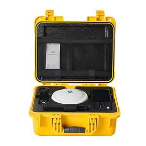
Robustness and Portability
As the surveying devices are meant to function outdoors in distinct climatological circumstances, they must be robust and portable. A majority of these instruments withstand moisture, dust, and extremes in temperature, embodying such factors as IP (Ingress Protection) ratings. They are specifically designed with portability in mind and can be carried effortlessly. While robust equipment guarantees reliability and durability, portability factors in their efficacious deployment during field surveys, and crucially, space saving without compromising either.
Assess Accuracy and Precision Needs
Identifying the essential degree of accuracy and precision for a specific survey task is fundamental in choosing the required surveying equipment. review projects like land subdivision will require equipment with simple positioning accuracy metrics. Conversely, construction or infrastructure projects may demand tools with several millimeters of precision. Take notice of the type of work that will be performed. Certain applications call for equipment that can operate under extended ranges with superior accuracy for topographic analysis or geospatial surveys.
Evaluate Project-Specific Requirements
Identify specific project demands and make an informed choice based on factors like the terrain type, survey size, and deadline. Simple or small-scale surveying endeavors would utilize handheld GPS devices or a total station. Larger or more sophisticated projects may require full stations with robotic capabilities or 3D laser scanning. Determine the equipment's purpose for the job at hand, and use it; equipment signs designed for particular applications are likely to yield better results than general-purpose tools.
Budget Considerations
Budget invariably plays a critical role when selecting electronic surveying equipment. Such affording equipment as a simple total station or a GPS unit can do wonders for small firms or short-term projects. Premium devices, however, with more enhanced features might be required for larger or prolonged projects due to their efficiency and accuracy. Weigh the costs against long-term benefits: investing in advanced technology is likely to pay back in reinforcing project execution within time and with increased accuracy. Rental options can also be explored if such a project is short-lived and does not require long-term use.
Assess Software and Compatibility
It might be worth considering the electronic surveying equipment's software compatibility with other relevant systems, such as GIS or CAD. Many contemporary instruments offer advanced data processing and analysis systems. Checking which tools might be most productive when working with existing workflows is a way to assess for that. Moreover, equipment integrated or designed to use similar software interfaces will help capture, process, and manage data efficiently in a more seamless manner. When selecting equipment, the post-processing software and compatibility with field data collection must go hand in hand, as data management and analysis have become a necessary step for the surveyors.
Robotic total stations survey and measure from a distance with minimal intervention. Hence, they are a huge time-saver and more efficient when used in construction projects where the surveyor must check the instruments' positions constantly.
GPS surveying equipment uses a global satellite system to determine precise positions on Earth by measuring the time taken for signals to reach the receiver from multiple satellites.
A digital level is an electronic advancement of traditional leveling that automatically reads height measurement employing electronic sensors for speed and accuracy.
Accuracy is extremely important when surveying since even minor errors cause huge problems in engineering and construction and legal issues in land surveying. That's why special attention is payed to choosing electronic surveying equipment to ensure their high accuracy.
Surveying data integration relies heavily on advanced surveying tools with capabilities to communicate and process data for GIS and CAD systems to support multiple types of projects.